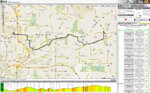
Citizens for Progressive Transit has developed a fantastic tool for multi-modal trip planning in the Atlanta region. Based on familiar Google Maps, A-Train (great name) gives the user lots of options important to walkers, bikers and transit riders. I am particularly excited about the Bike Triangle shown when you query a bike or bike/transit trip. It’s a way to ask the use to describe what’s important to them: terrain (hills), facility (street/sidewalk/trail) or distance. Depending on what kind of rider you are, this will have a different implication on what route it proposes. The best part is the green/red terrain indicator along the bottom for your trip to highlight big hills ahead.
In general, the idea behind multi-modal trip planners is to get the average user into a mode-neutral mindset. The only thing with this one is that the developer/sponsor’s intention shines through in that it does not provide driving directions. A comprehensive trip planner would have all available options and allow the user to compare them to see what is the best trip for their needs. This is understandable though, since many of the trips in Atlanta would be impractical or unfeasible all together for biking, walking or transit. Driving would always win. For now – let me just say this is a great tool and I hope to see it developed further.
It’s hard to tell exactly who worked on it and when it was developed (seems like it dates back to 2007), but it’s got a lot of useful features for multi-modal trip planning even by today’s standards. Keep an eye on this blog for more posts about multi-modal trip planning as the semester goes on. With the arrival of our newest professor, Dr. Kari Watkins, and my personal interest in this area, it will be a frequent topic!


The creator is David Emory (http://openplans.org/team/david-emory/) formerly of ARC and now of Open Plans. He’s even a GT grad! You can look forward to components of the trip planner being integrated into the new Open Trip Planner being overseen by Tri-met with many coding partners.
So I just used this to spec out a trip I am taking on Friday to the north perimeter, and I don’t really see what this currently adds that the normal Google transit directions don’t already have. Am I missing something?
My biggest problem with these algorithms as they currently manifest themselves is that they assumes bike/transit passengers want to minimize ride distance with the same preferences as pedestrian/transit passengers. Case in point: if I have a bike and want to get somewhere on MARTA, there is no way on earth that I would wait on tenth street for the 12- I’ll ride to Midtown.
I don’t fault those who are working on these problems; I certainly could not write anything better. Hopefully as things get more advanced, the tools will be more useful to people like me.
And why isn’t the Georgia Tech or Emory Shuttle service on Google Transit? The best way from Midtown to Druid hills is the Emory shuttle (at peak times). Google directions gives the best path as walk to the 12 (also silly when you consider the Tech Trolley), MARTA to Lindbergh, 6 to the CDC.
Thanks for showing us this post i got a lot of knowledge from this article which you tell us your technology ,i also want that type of website that tell about more information which we want from this article..